How to pass the TfL Topographical Skills Test - Ultimate guide 2025

To become an PCO driver in London, you need a valid PCO licence or, to use its correct name, a private hire driver licence (PHDL). These are issued by Transport for London (TfL) and drivers must pass a few exams to get one, including the Topographical Skills Test.
You only get two attempts to pass each TfL test, so it’s essential to be well prepared. To help you succeed more quickly, we’ve created a helpful guide packed with expert insights, drawing from Uber’s training course materials and a wide range of TfL sample questions.
- What is the TfL Topographical Skills Test?
- Who needs to take the topographical assessment?
- How do I book a TFL topographical test?
- How do I prepare for the topographical assessment?
- What score do I need to pass the topographical test?
- Extra training resources
What is the TfL Topographical Skills Test?
In simple terms, topography means using maps. So this test is mostly about map reading skills or route selection, while checking your basic knowledge of London geography.
The goal of this test is to ensure that PCO drivers can navigate London without relying on a satnav. While EVs come equipped with advanced technology, including built-in navigation systems, it’s still important to be prepared for situations where they might not be available.
This is one of three TfL tests that London private hire drivers must pass to get a PCO licence. The other TfL exams you need for a PCO licence are the two-part English Language Requirement (ELR).
Otto Car has ultimate guides on how to pass the TfL English test and SERU training, plus another on how to get a PCO licence . Here, it’s all about the Topographical Skills Test. Let’s get moving.
Who needs to take the topographical assessment?
All new TfL applicants for a PCO licence must pass the topographical skills assessment, aside from the following people:
- Previously licensed Private Hire Vehicle (PHV) drivers (i.e. you have already passed this TfL test)
- Licensed London taxi drivers (London and suburban drivers)
- Professional London tourist guides (e.g. Blue Badge Driver Guide)
Drivers who are simply renewing their PCO licence don’t have to retake the test, so long as it’s not yet expired. If your licence has run out in the past few weeks, TfL may allow a grace period (i.e. no retake) but only if you have a credible reason for the delay.
How do I book a TFL Topographical Test?
Once you submit your PCO licence application to TfL, you’ll get a date to attend a Topographical Skills Test Centre. This is at the official TfL premises in either Pier Walk (North Greenwich) or West Kensington.
For booking queries, email the TfL Topographical Team at tphtopo@tfl.gov.uk or phone on 0343 222 4444 (charges may apply).
Tip: You’ll need a confirmed booking to do this assessment - you cannot attend without a test date reservation.The test costs £36 and a retake is £16. Many Uber drivers worry about what happens if you fail a topographic test. You must pass the exam on either the first or the second attempt. Otherwise, you have to reapply for the whole PCO licence.
And if this happens, Uber says that you will get a partial refund on the TfL licence application fee.

How much does the Topographical Skill Test cost?
The test costs £36 and a retake is £16. Many Uber drivers worry about what happens if you fail a topographic test but there is no need to panic. With our help, you can nail this.
That said, you must pass the exam on either the first or the second attempt. Otherwise, you have to reapply for the whole PCO licence.
If this happens, Uber says that you will get a partial refund on the TfL licence application fee.
How do I prepare for the topographical assessment?
Before you take your topographical test, there are a few practical tips to keep in mind that can help boost your confidence. Here’s what you need to know:
- Navigation tools: All answers are entered using a mouse, not a keyboard. You'll need to click and drag the maps to move around, and zoom in using your mouse's scroll wheel. These actions can feel unfamiliar under pressure, so it’s a good idea to practice them ahead of time.
- Time management: You’ll have 90 minutes to complete just 29 questions, so there’s no need to rush. Take your time, work at your own pace, and try to leave a few minutes at the end to review your answers before submitting.
- Question format and scoring: There are 25 multiple-choice questions, which make up 25% of your final score. This is helpful as you’ll select your answer from a set of options. The remaining 4 questions focus on route planning and account for 75% of your mark. These require more detailed thinking, so be strategic and make sure you leave enough time to tackle them.
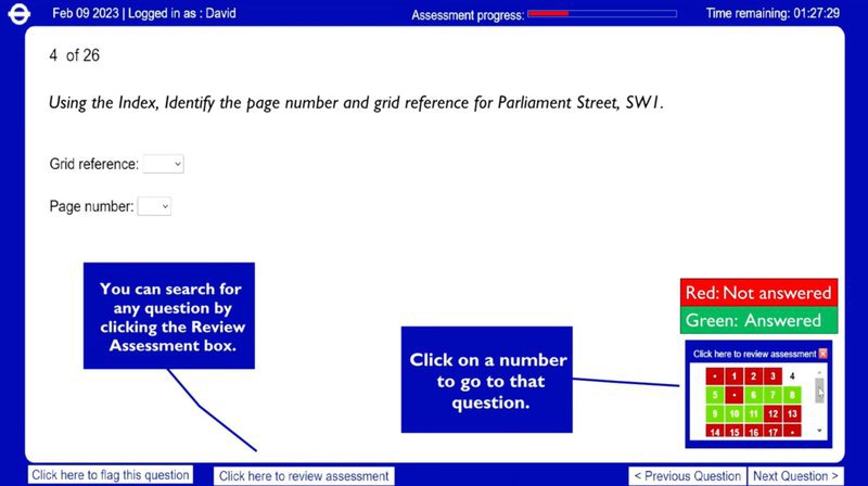
- Answer review: You can move back and forth between questions at any time before submitting your test. To switch between questions, click the ‘Review Assessment’ button and refer to the pop-up box in the bottom-right corner (see image 3). Completed questions will show in green. To skip and come back to a question later, click ‘Flag this question’.
Top tip:
You only commit to final answers once you press the ‘Submit’ button at the end. After that, no more changes are allowed, so always use the ‘Next Question’ button to move between the sections and come back to it at the end if you’re unsure.
Did you know?
Uber runs free training sessions for the topographical test students, including mock exams with the trainers at its Green Light Hubs.
What are the questions on the TfL Topographical Test?
As we’ve explained above, there are two main types of question: multiple choice and route planning.
However, TfL says that the test actually checks four different aspects of your map-reading skills.
- Index-based questions
- General topography
- Planning a route
- Compass-point questions
Section 1: Index-based questions
This is how to use the index of a London street atlas (i.e. book of maps) to find places. You’re given a copy of the Master Atlas of Greater London (also known as the A-Z) and must provide the correct information for a specific location or landmark.
Example question:
Locate the grid reference and the page number for Addington.
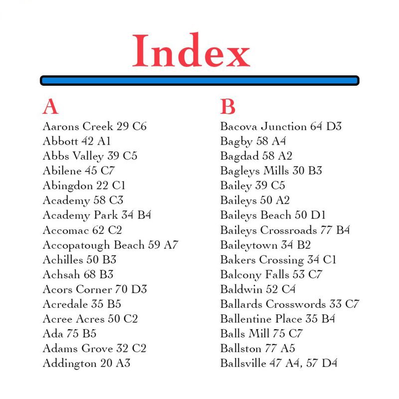
How to work it out:
In a standard index, the names of places are arranged in alphabetical order. Scroll through these until you find the exact location, then note the grid reference and page number.
In this example (see image 4) the page number is on the left (i.e. Addington is on page 20), and the grid reference is the code on the right (i.e. Addington is at A3).
It’s wise to practice with the Master Atlas A-Z for Greater London before the test. You can buy one from Amazon or Uber has good condition copies for drivers to use at the Green Light Hub.
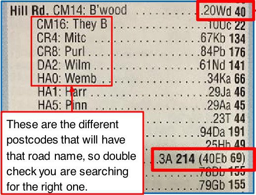
Popular street names, such as Hill Road (see image 5), are often used in multiple places and long roads might span more than one area. Postcodes are the clue that helps you to solve this.
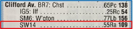
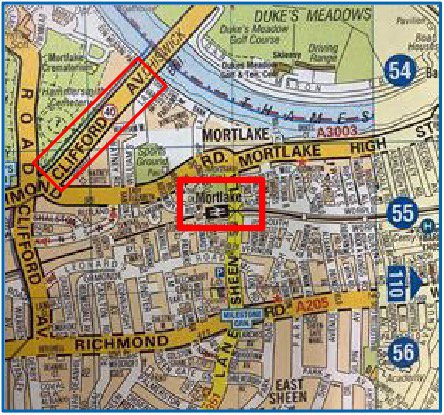
Learn how to use grid references in questions. For instance, if you need the nearest train station to an address (e.g. Clifford Ave, SW14).
Once you get the correct page and grid-reference from the index (check the postcode) you’ll see the closest station is Mortlake (images 6 and 7). In central London, this is easier to do on the large-scale pages.
Top tip:
Locations which begin with the word ‘the’ list this after the main description in the atlas index. For example, ‘The Shard’ is written as ‘Shard, The’.
Did you know?
Blue words in the index show areas of London (e.g. Hounslow), while places of interest (e.g. Houses of Parliament) are in red. There are also special pages for public transport stations and hospitals.
Section 2: General topography
This involves using the map in a standard atlas to identify directions between points or locations.
Example question:
What direction is London Heathrow Airport from Central London?
How to work it out:
First, locate a map where both Heathrow and Central London are on the same page. Then decide the direction of travel to move from one location to the other. The answer is to go west.
Top tip:
Get familiar with the most popular abbreviations (i.e. shortened words) used in the London Master Atlas. For instance, ‘Courtyard’ is often shortened to ‘Ctyd’ and ‘Boulevard’ is ‘Blvd’.
Did you know?
Common abbreviations are in the section of the Master Atlas titled ‘How to use this index’.
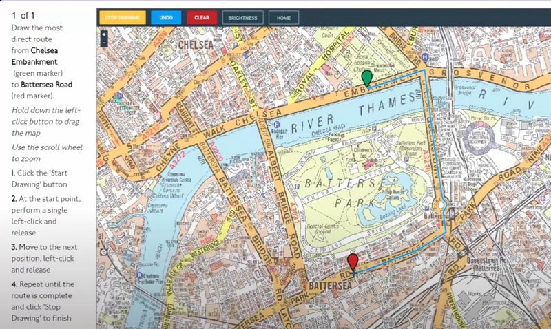
Section 3: Planning a route
These four questions will each show two different points on a map, and ask you to draw the best route between these locations. This section has the most marks (75%) so it’s vital to get it right.
To understand how these questions work, start by watching the TfL video (image 8). It shows what this part of the test looks like on a computer and how to use the software. This only takes 6 minutes.
Image 8: TfL video on route planning questions
How to work it out:
Planning routes is mostly common sense but make sure you avoid these common mistakes.
- Fail to follow the most direct route (i.e. this is not necessarily the fastest one)
- Ignore important map symbols (e.g. one-way systems or roundabouts)
- Arrive at the wrong end location (i.e. going to a nearby drop-off, not the point on the map)
Top tip:
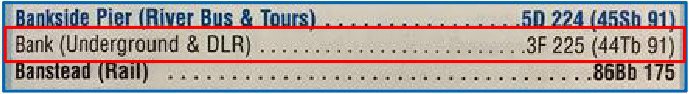
Enlarge a map to see road markings before you plot a route. You can zoom into the digital map (i.e. use the mouse scroll-wheel). For central London areas, check if it’s on the large scale pages.
For example, Bank station is on page 91 (image 9) but it’s also shown at large scale on page 225 in more detail.
Did you know?
The standard road-markings of the maps in the topographical test are explained on the ‘Reference’ pages of the London Master Atlas. For example, red arrows indicate the one-way streets.
Section 4: Compass-point questions
These check if you understand directions with compass points (i.e. North, South, East and West).
Here, you must use these basic compass directions to answer questions about specific scenarios.
Example question:
Start at junction 1 and travel two streets east, then one street south. What junction are you at now?
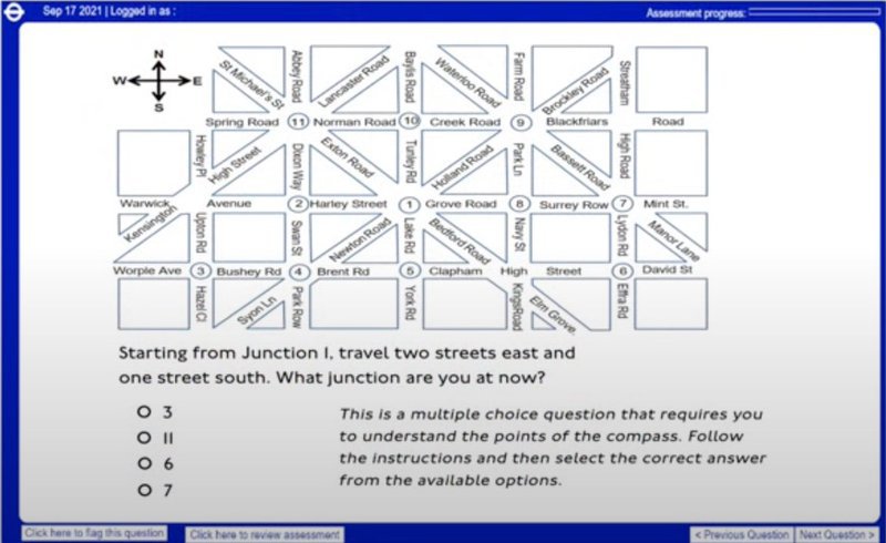
How to work it out:
Unless stated otherwise, North is always shown as upwards on a map. Imagine a clock face with the compass directions as numbers. The correct order from the top is: North, East, South, and West.
Once you know this, it’s easy to follow these directions. Do not get distracted by diagonal roads unless the question says so (e.g. travel north-east). In this case, the answer will be junction 6.
Top tip:
Compass directions might be included as arrows in the top-left corner of the map (image 11). If not, a good way to learn the correct order (i.e. NESW) is to remember: Never Eat Soggy Waffles.
Did you know?
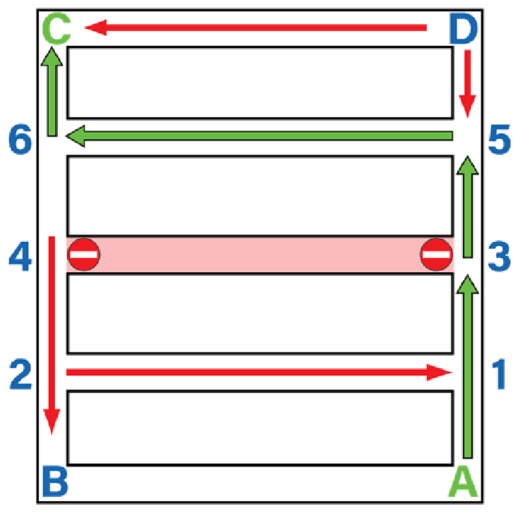
You might get a grid that checks if you recognise road closures or one-way signs, rather than compass points. In image 12, you must give correct directions to go from A to C (answer in green).
What score do I need to pass the TfL Topographical Test?
You must score at least 60 out of 100. This sounds high but is only slightly more than half marks. If you stay calm and use the time carefully, you should pass easily. Good luck.
Extra training resources
- Various firms sell topographical training courses but most people don’t need them.
- The official TfL topographical skills test page contains advice on the TfL website.
- Book a free topographical training session at the Uber Green Light Hub on the Uber website.
Take the next steps with Otto Car
Getting started as an Uber driver can feel complex but you’re not alone. Otto Car is the UK’s largest provider of vehicles to private hire drivers and we do our best to support drivers throughout their whole career.
Discover how easy it is to own or rent a vehicle with Otto Car. Get free expert advice from our team and explore our wide range of cars available in London with our hassle-free Rent to Buy or PCO Car Hire plans.
Interested in learning more? Enquire about the vehicle that’s caught your eye, visit one of our London hubs, or give us a call on 0330 113 2965 – we’d love to help!
And if you haven’t already, sign up to our newsletter to be a part of a growing community of thousands of drivers. Get exclusive offers, industry news, EV tips, and more – all delivered straight to your inbox.